Scale: 105 meters = 100 km = 100 kilometers
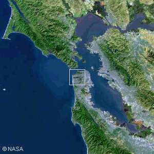
The San Francisco Bay AreaThis image shows the Bay Area from an altitude of about 200 km (125 miles), about half the distance to the International Space Station at 360 km. We are looking down on the homes and businesses of about 7 million people. All of San Francisco Bay is visible in this picture taken by a Landsat satellite. Some prominent features include the Farallon Islands at the western edge of the image, due west of San Francisco. Directly north of the Farallons is Point Reyes National Seashore. The San Andreas Fault runs along that narrow bay to the east of Point Reyes and continues southeast passing just west of San Francisco before heading down the peninsula along Crystal Springs Reservoir. The islands visible in the bay are Angel Island (north of the City) and Treasure Island (just off the northwest corner of the City). Treasure Island is near the midpoint of the San Francisco-Oakland Bay Bridge. Copyright © 2016 by Bruce Bryson |
||||||||||||||